Wednesday, August 3, 2011

Build Your Own Ladder Golf Set Using Official Dimensions

There are quite a few variations of rung geometry, both horizontal/vertical spacing and diameter. There are no official dimensions so I chose to go with spacing consistent with the most reliable source, laddergolf.com, which says:

Glossary of Terms:

Bolas: A Bola consists of 2 golf balls attached together with a piece of nylon rope. Golf Balls are spaced 13” apart.
Ladder: The ladder is the structure that consists of 3 steps each spaced 13 inches apart.
Steps or Rungs: Each ladder has 3 steps. The top step is worth 3 points, the middle 2 and the bottom 1 point.
Toss Line: The line that the players tosses from. Officially is set to 15 feet. For backyard games 5 paces works fine.
By using vertical pieces about 12” in length after the T’s are assembled it gives a spacing of about 13”. I chose to go with 3/4” PVC for durability reasons. Many people complain that 1/2” cracks or breaks after a fair bit of use.


Ladder Golf DIY Dimensions

Step 1: Materials
For 1 Rack
  • 19ft. of 3/4” PVC straight pipe
  • 2x 3/4” PVC 90 elbows
  • 6x 3/4” PVC Tees
  • PVC Glue
For 2 racks, double the above materials.

2 Sets of 3 Bollards:
  • 12’ of ⅜” rope
  • 12 golf balls
  • Some masking tape
  • Something to melt the ends of the rope with
Optional: Spray paint (your choice of color) - I suggest using “Krylon Fusion for Plastics”

Step 2: Cutting and Drilling
  • Cut the 18ft of 3/4” PVC into 5x24” and 8x12” pieces.
  • Drill a 3/8” hole through each golf ball (Be careful with newer golf balls that have a liquid core... it could get messy!)
Step 3: Painting (Optional)
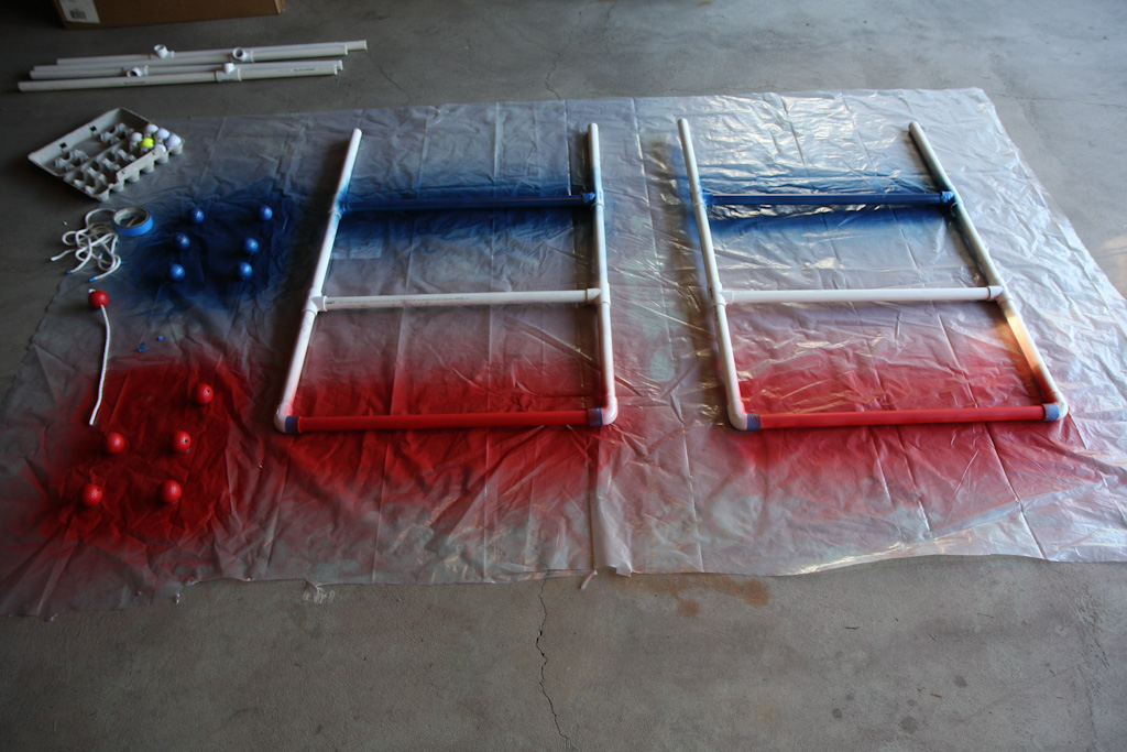
  • Before you assemble things is a great time to paint things to make the set a bit more playful and colorful. I chose to go with patriotic colors Red and Blue, leaving one rung PVC White. And colored different bollard sets red and blue.
  • Lay the pieces you want to paint out on a piece of plastic or cardboard and spray away. Make sure to get an even coat or two.
  • Give the paint plenty of time to dry

Step 4: Cutting and Melting
  • Wrap tape around the 3/8” rope every 24” (This will keep the rope from fraying when you cut it, and aid in the melting process)
  • Cut in the middle of each piece of tape
  • Melt one end of the pieces of rope using a lighter (Be careful and make sure that the melted portion doesn’t get larger than the 3/8” otherwise it won’t fit through the golf balls!)
  • Tie a knot in one end of a piece, thread two balls on, and tie a knot on the other end making sure the balls are 13" apart. Cut the excess rope after the knot and melt the second end using the same process with tape as above.
  • Remove the tape
Step 5: Assemble
  • Before you begin gluing think about how you are going to store and transport the set, which will tell you which joints not to glue to allow disassembly. I glued the entire rack except for the feet to the frame.
  • Glue the desired joints and let the glue set.
Step 6: Play!!!!

Monday, July 11, 2011

Download and Google Map Lowrance iFinder H2O Trail Data


I'm creating this post because there wasn't really a consolidated step by step on how to get from the GPS SD memory card (or MMC as Lowrance calls it) to the computer, to the correct file type and then to a presentable fashion in Google Maps.


Step-by-step:
1. Save your trail data to the memory card by going to Menu -> System Setup -> Transfer my data. Choose Save, then name the file and choose Save Data.
2. Remove and plug in your memory card to a card reader connected to a computer
3. Copy the previously named .USR file from the memory card somewhere on your computer
4. Download, install and run GPSBabel (free). For the input file select Lowrance USR and locate the file on your computer. For the output file, select GPX XML and name the output file. In the Translation Options section you can choose what types of data you want to convert and in this case all we're interested in is Trails. Under More Options I like to check Preview in Google Maps, just to make sure I have the right maps before proceeding. Click Apply.

5. Go to www.gpsvisualizer.com and choose your converted GPX file.
6. From here I like to see which trails I actually want to show and if any manual data modification is necessary. Then I use a text editor, Notepad++ if you don't have a favorite, to make the fine tune adjustments before repeating step 5.
7. You can download the map for local desktop use only, send a temporary link to your friends, or request a Google API Key and replicate the map on your own site like I will hopefully do in the next couple posts.


Enjoy!

Wednesday, June 29, 2011

Mt. Marcy by way of Johns Brook Trail

Last weekend myself, my girlfriend and three of our friends climbed Mt. Marcy, the highest point in NY. It was a great accomplishment for me (as well as a few others in the group) for a couple of reasons. It was my first overnight hike in addition to being the furthest (14 miles) I've hiked in a single day, the record was previously 11 miles to Buttermilk Falls that I did more than a year ago. I've also never planned a hike for such a large group that involved considerable research and the right gear.

Planning:
For those of you planning to hike Mt. Marcy there are three different (primary) ways to ascend Mt. Marcy. At 7.4 miles, the Van Hovenberg Trail is the easiest and shortest, starting from the Adirondack Loj (aka the ADK). The second route, the one we chose to hike, is via Phelps and Johns Brook Trail at around 9.1 miles each way with the trailhead at the Garden in Keene Valley. The third and most difficult ascent is via the Great Range Trail at 13.5 miles each way. We chose Johns Brook because we wanted to make it an overnighter and it had the most camping sites and lean-tos along the way, as well as Johns Brook Lodge (JBL) 3.5 miles in for water refilling.

After selecting our desired trail the next step was to create a rough itinerary and list of gear and supplies required for the trip. Here's what I ended up packing. Note that

Wearing:
- Non-cotton shirt
- Athletic shorts
- Hiking socks
- Hiking boots
- Underwear

Packing: (In a hiking backpack)
- Extra non-cotton shirt
- Extra Hiking Socks
- Extra Underwear
- Rain Jacket
- Fleece for cold/night
- Non-cotton Long sleeve shirt for another layer
- Bug Spray
- Sunscreen
- Toothbrush/Toothpaste
- Wipes
- Deodorant
- Plastic bags for feet
- Camelback (100 oz)
- Nalgene (1L)
- Sunglasses
- Sleeping Bag
- Headlamp
- Map
- Tent
- Bearproof canister

Optional:
- Rope
- Knife
- Compass
- First Aid
- Duct Tape
- Camera
- GPS
- Phone
- Water purification

- Along with this we also had a meal and a fresh change of clothes waiting in the car for when we returned the second day.

All said and done my pack weighed 45lb with water but I had an oversized (and overweight) pack, a $5 heavy sleeping bag and a bunch of food and supplies (most of the optional stuff) that I didn't need. In the future I'll shoot for 30-35lb.

The Trip:
With all of our gear loaded up in the back of the Rav, we headed off to Keene Valley around 2pm on Saturday for an arrival at the trailhead around 4:30pm. The first 3.5 miles to JBL, and our campsite, took 2hrs 5mins. Compared to the walk back it seemed like a cakewalk with all of that gear, food and water. By 7:30pm we had our tents set up and were settling down for the evening for a nice game of ERS and storytelling. The next morning we were up at 6am, breaking camp and eating breakfast. We started our ascent at around 7:15am with smaller, lighter packs, leaving our camping gear behind and it took us 4hrs and 10mins to summit. The hike up was very damp, but a lot less difficult that I expected. Instead of a sloped well-beaten path it was a narrow fairly flat path with steep rock/bouldery climbs in between. It made for by far one of my most interesting and enjoyable climbs. Instead of killing our calves on a boring incline it was more like rock climbing/jumping which made things much more entertaining. The last half mile or so to the summit is above the treeline for the most part and costs of slippery mossy rock faces and outcrops. The summit was easily 10-15F colder than a few hundred feet lower, partly because of additional the moisture and wind. The visibility was probably a few hundred yards, pretty disappointing for such a large undertaking compared to anything we had done previously.

We decided to take our summit lunch back at a warmer portion of the trail 0.5miles down. Our progress descending was much slower than anticipated. We made it back to our camp in 3hr 45 (only 25 minutes faster than the ascent). Because it was a lot of rocks and roots the downhill was much more strenuous on our knees and hip flexors. Where things really took a turn for the worse was when we had to put on our heavy packs. The 3.5 miles back to the car seemed never ending but we managed to make it back in 1hr 40 mins, on a portion of the trail where the elevation change was mostly a wash.

Takaway:
In all, it was a great experience. Everything went according to plan and no one got injured despite a few close calls. The summit and hiking conditions were a bit disappointing and the walk back was very taxing, but the hike up and feeling of accomplishment totally made it worthwhile.

Resources:
Peakbagger - lists the two routes as Van Hoevenburge Trail and Feldspar (Tahawus), has a great list of trail reports by other hikers
HighPeaksClimbing - Lists Adrondack Loj and Garden Parking Lot as two trailheads, refers to Phelps trail (turns into Johnsbrook trail) as the popular route from Garden Parking lot.
Keene Valley Hike Shuttle
My Big Adventure- very detailed picture hike using AdLoj route
Natural Born Hikers- another great photoblog using AdLoj route
Description of Johns Brook Trial
Description of Johns Brook Trail with Camping
Grace Camp